Elk Lake
Watershed: Elk River Chain of Lakes Watershed
Primary Inflows: Torch River and the Upper Chain via Lake Skegemog
Primary Outflows: Elk River
Surface Area: 8194 acres
Shoreline: 28 miles
Maximum Depth: 195 feet
Public Access Sites: 37
Primary Inflows: Torch River and the Upper Chain via Lake Skegemog
Primary Outflows: Elk River
Surface Area: 8194 acres
Shoreline: 28 miles
Maximum Depth: 195 feet
Public Access Sites: 37
Description:
Elk Lake is positioned between Lake Skegemog and East Grand Traverse Bay adjacent to the Village of Elk Rapids in Antrim County. It is the last in a long chain of 14 lakes called the Elk River Chain of Lakes. Elk Lake discharges into East Bay via the Elk River, contributing approximately 60% of the water that flows into Grant Traverse Bay (the annual average flow is about 763 CFS).
A dam was first constructed on the Elk River in the 1860's. The present dam impounded most of the original river channel and raised the water level in Elk and Skegemog Lakes about five feet above pre-dam conditions. Upstream of the dam, the rocky bottom of the flooded river channel is visible when the water is clear. Unfortunately, the dam blocks fish migration between the Chain of Lakes and Lake Michigan. However, the dam does provide benefits in that it is a barrier that prevents invasive species from moving upstream into the Chain, such as sea lamprey. To this day, the dam is still used to produce hydroelectric power.
Elk Lake is Michigan’s second deepest inland lake (~195’) and 14th largest lake in terms of surface area (~8,200 acres). It is an oligotrophic lake, which means that it has low biological productivity, is nutrient poor, but with abundant dissolved oxygen throughout its depths. Because of Elk Lake’s oligotrophic status and absence of soft sediments conducive to aquatic plant growth, aquatic plants are not common. High levels of calcium carbonate in its waters impart a characteristic emerald green color in summer.
Public access sites include an MDNR boat launch, county and township parks, many road endings and pedestrian access easements, and numerous parcels owned by the Grand Traverse Regional Land Conservancy. Extensive and important wetlands are found on the northeast shore near Kewadin, and on the south end adjacent to Battle Creek. Elk Lake’s named tributaries include Battle Creek and Williamsburg Creek.
The fisheries of Elk Lake were recently thrust into the spotlight when it was found that a unique lake trout strain inhabited the lake. MDNR fisheries biologists continue to study the Elk Lake lake trout to better understand its life history, particularly its success at deep-water spawning, and how this strain’s characteristics might benefit lake trout populations in the Great Lakes.
|
Golden Brown Benthic Algae
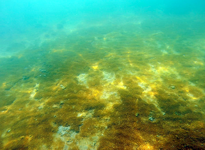
Golden-brown benthic algae (GBA) is not new to Elk Lake, but its prevalence in recent years seems to be increasing. More riparians are asking questions about this aesthetic nuisance in the near-shore bottomlands. GBA has also been found in nearby Torch Lake. On October 28, 2016, Becky Norris from Three Lakes Association presented information on the Golden Brown Algae (GBA) study to the Freshwater Summit in Traverse City Michigan. While this information was geared toward findings from research studies performed on Torch Lake in 2015 and 2016 with the assistance and guidance of Drs. Pat Kociocek, Rex Lowe, and Jan Stevenson, the information in the presentation is useful. Below are the slides and notes from the summit. GBA Freshwater Summit Presentation 10-28-2016 GBA Freshwater Summit notes |
Monitoring and Research:
Elk Lake is monitored every three years through the Watershed Council’s Comprehensive Water Quality Monitoring (CWQM) Program for dissolved oxygen, specific conductivity, pH, nitrate-nitrogen, total nitrogen, total phosphorus, and chloride levels.
Water transparency, chlorophyll-a, and water temperature are also monitored in Elk Lake each summer by volunteers as part of the Watershed Council’s Volunteer Lake Monitoring (VLM) Program.
The Elk River Chain of Lakes Watershed Plan Implementation Team meets regularly and is working to protect the lakes in the Chain.
Report of the 2017 Sandbar Pollution Study - Prepared by Becky Norris for the Three Lakes Association, the Torch Lake Protection Alliance, and the Elk-Skegemog Lake Association
Publications:
Elk-Skegemog Lakes Profile (2011)
Elk-Skegemog Lakes Profile (2008)
Grand Traverse Bay Watershed Protection Plan (2005)
Fish of the Elk River Chain of Lakes (2001) - Hard Copy only. $
Additional Resources:
See additional resources on our Aquavist page.
View an interactive map of Elk Lake, including public access sites, at Michigan Fishweb.
A wide variety of maps for this area are available online at the Michigan Natural Features Inventory (MNFI) Data Resources page.
Information about Threatened, Endangered, and Special Concern species in this lake’s watershed is available on the Michigan Natural Features Inventory (MNFI) website.
Learn about safely eating fish from this lake in the Michigan Fish Consumption Advisory.
|
Elk-Skegemog Lakes Association
The purpose of the Elk-Skegemog Lakes Association is to promote an understanding and appreciation of the rights of and responsibilities of owners of riparian lands. They take actions that are necessary or desirable to protect and preserve the environment of the area of the Elk-Skegemog watershed, including connecting lakes, streams, and wetlands. They help solve problems common to the members, involving lake level, water safety, water pollution and indiscriminate or over development of the waterfront. They cooperate and interact with federal, state, and local government bodies and other organizations concerned with water quality and environmental issues. ESLA also undertake periodic scientific tests of the quality of the water in Elk and Skegemog Lakes and take actions, and encourage others to take actions, which preserve the clean and pure waters contained therein. |


