Inventories and SurveysOur water resource inventories and surveys are one of many approaches that the Watershed Council uses to protect Northern Michigan's water resources. We have a long history of performing inventories and surveys for watershed management planning or as a service to lake associations, local governments, riparian property owners and others.
|
Aquatic Plant Surveys
We perform detailed aquatic plant surveys and use results to assist lake associations and others with aquatic plant management plans for, using survey results. These surveys are typically done lake-wide and provide information and maps about the location and densities of aquatic plant communities, aquatic plant diversity, invasive plant species, and fish habitat.
- Larks Lake Aquatic Plant Survey - 2020
- Pickerel-Crooked Lakes Aquatic Plant Survey - 2020
- Douglas Lake Aquatic Plant Survey - 2019
- Elk River Chain of Lakes Aquatic Plant Survey - 2014-15
- Black Lake Aquatic Plant Survey - 2014
- Black Lake Aquatic Plant Survey (2005)
- Burt Lake Aquatic Plant Survey (2016)
- Aquatic Vegetation Survey for Crooked and Pickerel Lakes (2008)
- Aquatic Vegetation Survey for Douglas Lake - Cheboygan Co. (2012)
- Aquatic Vegetation Survey for Lake Bellaire and Clam Lake (2013)
- A Cladophora Survey of Lake Charlevoix (1996)
- Larks Lake Aquatic Plant Summary (2009)
- Mullett Lake Aquatic Plant Survey (2007-2008)
- Mullett Lake Partial Aquatic Plant Survey Summary (2015)
- Paradise Lake Aquatic Plant Survey (2008)
- Paradise Lake Aquatic Plant Survey (1996)
- Pickerel-Crooked Lakes Aquatic Plant Survey (2015)
- Walloon Lake Aquatic Vegetation Survey (2013)
- Long Lake Aquatic Plant Survey (2008)
- Long Lake Aquatic Plant Survey (2005)
- Long Lake Aquatic Plant Survey (2013)
- Wycamp Lake Aquatic Plant Survey (2006)
GreenBelt Surveys
Road/Stream Crossing (RSX) Inventories
|
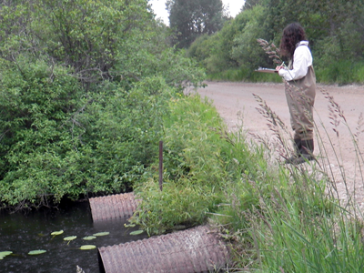
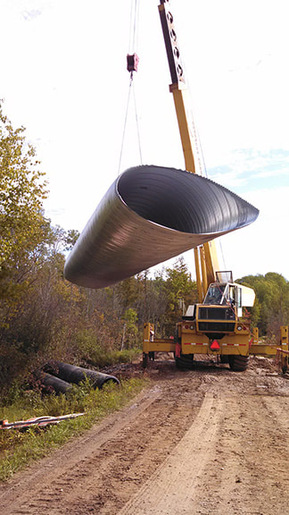
RSX inventories serve as a useful watershed management tool. They help identify sediment pollution entering surface waters from poorly designed, maintained, or aging stream crossing infrastructure. Inventories also reveal fish passage barriers due to perched culverts, as well as altered stream hydrology from inadequately designed or installed crossings. Performing regular RSX inventories allows road commissions and resource managers to note changes in stream and structure conditions over time, as well as rank RSXs as minor, moderate, or severe, as a means of prioritizing them for improvements or replacement.
RSXs that are improperly designed or installed, structurally failing, or no longer accommodate current stream conditions affect stream health. They can affect stream hydrology, prevent fish and other aquatic organisms from reaching up-and downstream reaches, increase water temperatures, and are sources of nutrients, sediments, bacteria, heavy metals, and other nonpoint source pollutants. In Northern Michigan, sediments pose the greatest threat to rivers and streams. Sedimentation can adversely impact fish and aquatic organisms by degrading their habitat and reducing water quality. |
Shoreline Surveys
Shoreline surveys are typically performed for lake associations to provide a lake-wide assessment of the shoreline. Every property is surveyed for signs of nutrient pollution, erosion, greenbelts, altered shorelines, and other relevant factors. Survey information is used to work with individual property owners to address any problems on the shoreline. Information about individual properties is kept confidential. View results of recent shoreline surveys below:
Shoreline Surveys - Find Your Score
Shoreline Survey Reports
- Walloon Lake Shoreline Survey Report (2020)
- Mullett Lake Shoreline Survey Report (2018)
- Lake Charlevoix Shoreline Survey Report (2018)
- Thayer Lake Shoreline Survey Report (2017)
- Torch Lake Shoreline Survey Report (2017)
- Black Lake Shoreline Survey Report (2017)
- Skegemog Lake Shoreline Survey Report (2017)
- Lake Bellaire Shoreline Survey Report (2017)
- Clam Lake Shoreline Survey Report (2017)
- Elk Lake Shoreline Survey Report (2017)
- Six Mile Lake Shoreline Survey Report (2016)
- St. Clair Lake Shoreline Survey Report (2016)
- Wilson Lake Shoreline Survey Report (2016)
- Ellsworth Lake Shoreline Survey Report (2016)
- Hanley Lake Shoreline Survey Report (2016)
- Intermediate Lake Shoreline Survey Report (2016)
- Benway Lake Shoreline Survey Report (2016)
- Scotts and Beals Lakes Shoreline Survey Report (2016)
- A Nutrient Pollution Shoreline Survey on Black Lake (2005)
- Lake Bellaire Shoreline Survey Summary Report (2008)
- Burt Lake Shoreline Survey (2009)
- A Nutrient Pollution Shoreline Survey on Lake Charlevoix (2007)
- Douglas Lake Shoreline Survey (2015)
- A Shoreline Nutrient Pollution Survey on Huffman Lake (2006)
- Lake Charlevoix Shoreline Survey (2012)
- Crooked-Pickerel Lakes Shoreline Survey (2012)
- Huffman Lake Shoreline Survey (2015)
- Lance Lake Shoreline Survey (2014)
- Mullett Lake Shoreline Survey (2008)
- Paradise Lake Shoreline Survey (2003)
- Round Lake Shoreline Survey (2014)
- Silver Lake Shoreline Survey (2014)
- Six Mile Lake Shoreline Survey Report (2008)
- Six Mile Lake Shoreline Survey Report (2000)
- A Shoreline Algal Survey of Torch Lake, Clam Lake, and Lake Bellaire (2010)
- Walloon Lake Shoreline Survey (2016)
- Walloon Lake Shoreline Survey (2010)
- A Nutrient Pollution Shoreline Survey on Walloon Lake (2005)
- Wildwood Lake Shoreline Survey (2014)


