|
Independent Risk Analysis for the Straits Pipelines
The State of Michigan conducted an independent, third party Risk Analysis for the 4.6 mile stretch of Enbridge’s Line 5 located in the Straits of Mackinac. A Independent Risk Analysis for the Straits Pipelines was developed by a team led by Michigan Technological University and directed by professor Guy Meadows of Michigan Tech’s Great Lakes Research Center. The team included 42 Researchers from nine universities, seven located in Michigan – UM, MSU, WSU, WMU, GVSU, OU, and MTU – and two outside Michigan – NDSU and LUC, as well as three consultant organizations, two independent contractors (former DoE and AFPM), and the National Oceanic and Atmospheric Administration’s Great Lakes Environmental Research Laboratory (GLERL). The report can be accessed in its entirety on the Michigan Petroleum Pipelines website, www.mipetroleumpipelines.com. The analysis evaluates Enbridge’s liability for a worst-case-scenario pipeline spill including the impact such a spill would have on Michigan’s economy and environment. The risk analysis will help inform a decision by the State on the final disposition of Line 5. A final report was submitted to the state on September 15, 2018. The final decision on the future of Line 5 is expected by October 1, 2018. |
Information from the Draft Risk Analysis Report comment period
SUMMARY OF THE DRAFT RISK ANALYSIS REPORT
Objective: The 1953 Straits Pipelines Easement makes Enbridge liable for all damages or losses to public or private property resulting from its operations at the Straits. It also requires Enbridge to maintain insurance or other financial assurance acceptable to the State covering its liability. An independent analysis by qualified experts of the consequences of a worst-case scenario spill is needed to establish the amount of the required financial assurance and to help guide decisions about the future of the Pipeline.
Identifying a “worst case” spill or release.
Scope of Work:
- Identifying a “worst case” spill or release
- Analyzing the fate and transport of oil or other product released
- Analyzing how long it would take to contain and clean up the worst case release
- Analyzing the short and long-term ecological impacts
- Analyzing measure to restore and mitigate the affected natural resources
- Estimating the amount of natural resource damages that would result
- Estimating the governmental costs that would be incurred
- Estimating all other economic damaged, public and private
Identifying a “worst case” spill or release
- “Largest foreseeable discharge of oil, including a discharge from fire or explosion, in adverse weather conditions” (40 CFR 194.5)
- Seasonal timing varied depending on focus of task
- Winter spill most difficult to respond safely and effectively
- Spring spill generates highest economic costs
- Summer spill poses the greatest risk to public health and safety due to seasonal change in population
- Five Tiers of Failure
- 3” pinhole leak shutdown in 3.5 minutes = 4,400 bbls or 184,800 gallons
- 3” pinhole leak shutdown in 13.5 minutes = 8,600 bbls or 361,200 gallons
- Rupture in both pipelines shutdown in 13.5 minutes = 16,800 bbls or 705,600 gallons
- Rupture in one pipeline, valve closure failed, manual shutdown in 2 hours = 29,000 bbls or 1,218,000 gallons
- Rupture in both lines, manual shutdown in 2 hours = 58,000 bbls or 2,436,000 gallons
- 4380 oil dispersal simulations conducted, covered a full year at 6 hour intervals
- Oil allowed to disperse for maximum of 60 days
- 2016 used to provide representative meteorological and environmental data
- Average lake temperatures were slightly above the long-term average
- Overall ice in 2016 was lower than long-term average
- Dispersal maps developed for shoreline oiling, surface area oiling, and amount of oil beached at shoreline locations
Oil Beaching
In general, Lake Huron shorelines are predicted to be at the greatest risk of oiling. In June, July, August and October, the model predictions indicated oil beached oil along Lake Huron shorelines.
The maximum extent of shoreline oiling (km) predicted for the Straits of Mackinac and adjacent Lake Michigan and Huron regions as associated with the meteorological, ice cover and water current conditions observed for February. Results depicted represent a total oiled shoreline distance of 711 km following an oil release date and time of 02/28/2016 at 1200 hrs from the central pipeline release point and a total dispersal simulation time of 60 days.
Lake Michigan coastline predicted to have 567 km of total oiled shoreline and Lake Huron 144 km.
Surface Oiling
Majority of simulations predict oils spreads mainly to Lake Huron surface waters – January, May, June, July, August, September, November and December.
The maximum extent of surface area oiling (km2) predicted for the Straits of Mackinac and adjacent Lake Michigan and Huron regions as associated with the meteorological, ice cover and water current conditions observed for April. Results depicted above represent a total surface area of 1745 km2 following an oil release date and time of 04/24/2016 at 1200hrs from the northern pipeline release point and a total dispersal simulation time of 30 days.
Containment and Cleanup Time
- Active shoreline cleanup estimated to continue 12-24 months
- Weather conditions affecting containment, recovery, and cleanup include: ice coverage, wave heights, wind speeds, and current speeds
- Analysis indicates that in every month there are conditions under which recovery of oil would not be possible due to wind and wave conditions.
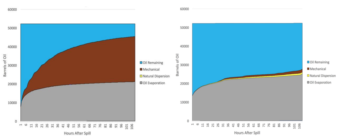
- “Good weather” simulation: 16,991.2 bbls recovered after 5 days
- “Real weather” simulation: 1,036.8 bbls recovered
Oil recovered as a function of time with no wind (left) and wind (right)
Public Health and Safety Impacts
Chemicals of Concern:
Areas of Concern: Shorelines of Emmet, Cheboygan and Mackinac Counties
Drinking Water: Public supplies and private drinking water wells would be at risk of oil contamination. However, the underground water flows towards the lake making the risk relatively low.
Overall Risks: Relatively low with no potential fatalities and chronic adverse health effects expected
Chemicals of Concern:
- Total Petroleum Hydrocarbons
- Petroleum-Related Volatile Organic Compounds: Benzene, Toluene, Ethylbenzene, and Xylenes (BTEX)
- Other Gases: Pentane, Hexane, Hydrogen Sulfide
- Polycyclic Aromatic Hydrocarbons: 16 US EPA Priority PAHs
Areas of Concern: Shorelines of Emmet, Cheboygan and Mackinac Counties
Drinking Water: Public supplies and private drinking water wells would be at risk of oil contamination. However, the underground water flows towards the lake making the risk relatively low.
Overall Risks: Relatively low with no potential fatalities and chronic adverse health effects expected
Ecological Impacts
Impacts:
Impacts:
- Mortality
- Physiological effects - developmental, immune or neurological problems
- Ecological effects – population and diversity loss, loss of reproductive potential
- Long-term disruptions to Great Lakes food web
-
Chemicals:
Natural Resources at Risk:
Restoration and Mitigation Measures
*Does not take into account any containment and recovery actions which would reduce impacts
Governmental Costs
Broader Impacts
Summary of All Costs
- BTEX – remain in the environment for about 6-10 days following a spill
- PAHs – bind to sediment and bioaccumulate, toxic to phytoplankton and zooplankton, bivalves, and juvenile/larval life stages of most species that form the base of the Great Lakes food web (greater concern)
Natural Resources at Risk:
- 12 unique habitats including Great Lakes marsh, open dunes, and wooded dune/swale complex, approximately 60,000 acres
- Parks and conservation areas: Mackinac State Park, Cheboygan State Park, Hiawatha National Forest, Michigan Islands National Wildlife Refuge, Dingman Marsh, French Farm Flooding State Wildlife Area, Beaver Island State Wildlife Research Area, and more
- 40 fish species including threatened and endangered Burbot, Coho, Chinook, Rainbow Trout, Long-Nose Sucker, Channel Darter, Pugnose Shiner, Cisco, and Lake Sturgeon. Fish that are bottom dwellers and fish in the near shore littoral zone will have higher exposure and more health impacts. Eggs and larvae will suffer the highest mortalities and longer-term populations level decreases resulting from a reduction in survival.
- 76 bird species - 22 have state, federal, international conservation status including Bald Eagle, Peregrine Falcon, Cattle Egret and Piping Plover
- Total of 47 state and federally listed species at risk
Restoration and Mitigation Measures
- Cost estimates for primary ecological restoration: $165 million - $1.3 billion, when containment and recovery are taken into account
- Primary restoration - actions that help return injured resources and services to baseline or the condition that would have existed had the incident not occurred
- Does not include compensatory restoration – actions taken to reimburse the public for interim losses between the oil spill and the return to baseline conditions
- Does not include provision or development of alternative drinking water sources
- Does not include costs for containment, recovery, and cleanup
- Estimates of natural and cultural resources restoration could reach more than $3.2 billion for a spill scenario that impacts 1075 km of Lake Huron shoreline
- Recreational fishing - $6.2 million
- Recreational boating - $32.5 million
- Park day visits and camping - $22.5 million
- Recreational beach use - $398.6 million
- Coastal property value loss – $1.3 million
- Commercial fishing - $1.6 million
- Commercial shipping - $43 million
- Water supply impacts - $181 million
- Michigan energy supply effects -$3.6 million
- Lost incomes for tourism and recreational related businesses - $679.7 million
*Does not take into account any containment and recovery actions which would reduce impacts
Governmental Costs
- $127 million - costs related to the direct response to oil spill of Line 5 would be reimbursable by Enbridge
- Broader negative effects on the regional and local economies = tax revenue reductions related to reduced visits by out of state tourists and the decline in direct economic activity to those affected businesses
- $24.3 million for Michigan
- $38.7 million for Wisconsin
- $112.4 million for the federal government
Broader Impacts
- Social License to Operate
- Lacking for Line 5
- Most people perceive the relative risks to outweigh the benefits
- State also faces loss of legitimacy
- Lack of public trust in the process of evaluating the safety of the industry and operation of Line 5
- Tribal Nations in Michigan
- Collective concern over existence and continue use of Line 5
- Potential damage to Tribal fishery, culturally significant plants, properties, and sacred sites
Summary of All Costs
SUBMITTING PUBLIC COMMENTS ON THE RISK ANALYSIS
|
Opportunities for Public Comment
Public Meeting – August 13, 2018 6:00 – 9:00 pm Boyne Highlands Resort Blue/Green Room 600 Highland Drive Harbor Springs, MI 49740 Online at the Michigan Petroleum Pipelines website: www.mipetroleumpipelines.com Standard mail Michigan Agency for Energy Attn: Line 5 Pipeline Study P.O. Box 30221 7109 W. Saginaw Highway Lansing, MI 48917 Email through the website: www.mipetroleumpipelines.com |
Focus For Comments
|


