Shoreline Restoration Projects
|
The Watershed Council can provide different levels of contract services for shoreline and streambank restoration needs. The first step is to complete our Shoreline, Streambank, and Wetland Questionnaire. After reviewing your questionnaire, we will contact you to discuss your options. This may include scheduling a site assessment where Watershed Council staff will visit your shoreline or streambank property, document the current conditions, and recommend courses of action. In some cases, a restoration plan or design is recommended to curb the progression of erosion and sedimentation, and "restore" the shoreline or streambank to its former condition. An effective method referred to as "biotechnical erosion control" provides the most cost-effective, environmentally friendly and aesthetically appealing alternative to controlling accelerated shoreline erosion. The Watershed Council can develop restoration designs based on this method, as well as apply for the required state and local permits and coordinate the installation of the project.
|
This video highlights a shoreline restoration project that was completed by Tip of the Mitt Watershed Council on Intermediate Lake.
|
Evangeline Township Park on Lake Charlevoix - Glenwood Beach Drive
The Evangeline Township Park at Glenwood Beach provides public access to Lake Charlevoix. Recognizing the need for a more user-friendly park that provides recreational opportunities while protecting water quality, the Township contracted with the Watershed Council to develop plans for a shoreline enhancement project, including a demonstration greenbelt.
The Evangeline Township Park at Glenwood Beach provides public access to Lake Charlevoix. Recognizing the need for a more user-friendly park that provides recreational opportunities while protecting water quality, the Township contracted with the Watershed Council to develop plans for a shoreline enhancement project, including a demonstration greenbelt.
|
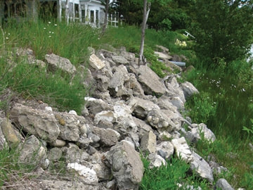
BEFORE
Large, broken pieces of concrete blanket the slope creating a hazardous approach to the lake. |
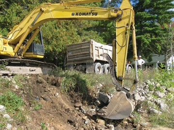
CONSTRUCTION
Harbor Springs Excavating started by removing the concrete rubble to create a clean slate for New Savanna Landscape Company. |
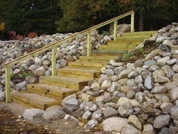
AFTER
Access to the lake can be gained safely by way of new stairs. |
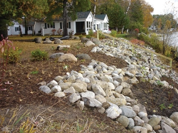
AFTER
Native planting pockets are incorporated into fieldstone revetment. |
"Evangeline Township is very happy with the new shoreline protection structure at Glenwood Beach,
it looks really terrific. It was great working with Tip of the Mitt, whose staff was pleasant and
professional, and whose guidance helped assure project completion."
Shannon McMaster, Boyne City Assistant Planner/Zoning Administrator
Streambank Restoration - Pigeon River
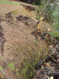
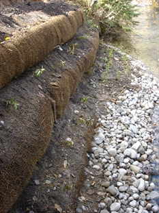
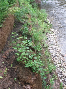
With the generous support of Mullett Area Preservation Society (MAPS), the Watershed Council provided bioengineering design, permit application services, and installation supervision to stabilize a stretch of Pigeon River stream bank. The bioengineering solution included using prefab soil lift structures made from coir (coconut fibers) and alternating with bare-root dogwood and ninebark shrubs. Cobble was installed at the toe of the streambank. In order to provide additional support to the streambank, the property owners have implemented a no-mow zone extending the length of the former slump. Installation was limited to hand tools to avoid further stress to the streambank.
With the generous support of Mullett Area Preservation Society (MAPS), the Watershed Council provided bioengineering design, permit application services, and installation supervision to stabilize a stretch of Pigeon River stream bank. The bioengineering solution included using prefab soil lift structures made from coir (coconut fibers) and alternating with bare-root dogwood and ninebark shrubs. Cobble was installed at the toe of the streambank. In order to provide additional support to the streambank, the property owners have implemented a no-mow zone extending the length of the former slump. Installation was limited to hand tools to avoid further stress to the streambank.
|
BEFORE
Approximately 35 linear feet on the Pigeon River slumped likely as a result of high water levels in early spring of 2008. |
AFTER INSTALLATION
The exposed face of the soil lifts can be seen. Dogwood and ninebark saplings are planted between the layers. |
1 YEAR AFTER INSTALLATION
Nearly one year after installation, the shrubs have begun to fill in and the slope remains stabile. Over time, the project will become less and less evident as the vegetation grows and the area blends in with the natural riparian areas. |
"Without the able assistance of the professional staff at TOMWC we would be stymied as to how to keep restoring various
problem areas of stream bank erosion on the Pigeon River that MAPS has been financing for many years."
Mullett Lake Preservation Society (MAPS)

